Archaeologists unearth secrets of artificial island older than Stonehenge in major underwater discovery
المصدر: GB News | Source: GB NewsArchaeologists have unearthed an artificial timber platform older than Stonehenge, concealed beneath what appears to be an artificial stone island.
Researchers from the University of Southampton made the discovery in Loch Bhorgastail on the Isle of Lewis, Scotland.
The crannog, a type of artificial island found throughout Scottish lochs, was originally constructed more than 5,000 years ago, making it older than Stonehenge.
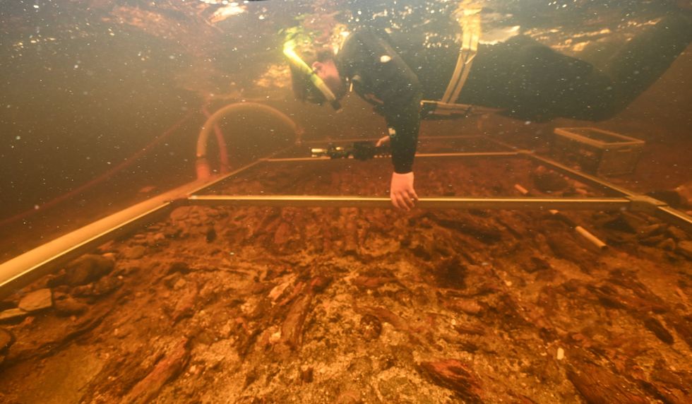
Although the presence of some wooden elements beneath the structure was previously known, the full scale of the timber foundation remained hidden until recent excavation work began.
TRENDINGStoriesVideosYour SayThe team's findings, which reveal how the island looks both above and below the waterline as a unified structure, have been published in the journal Advances in Archaeological Practice.
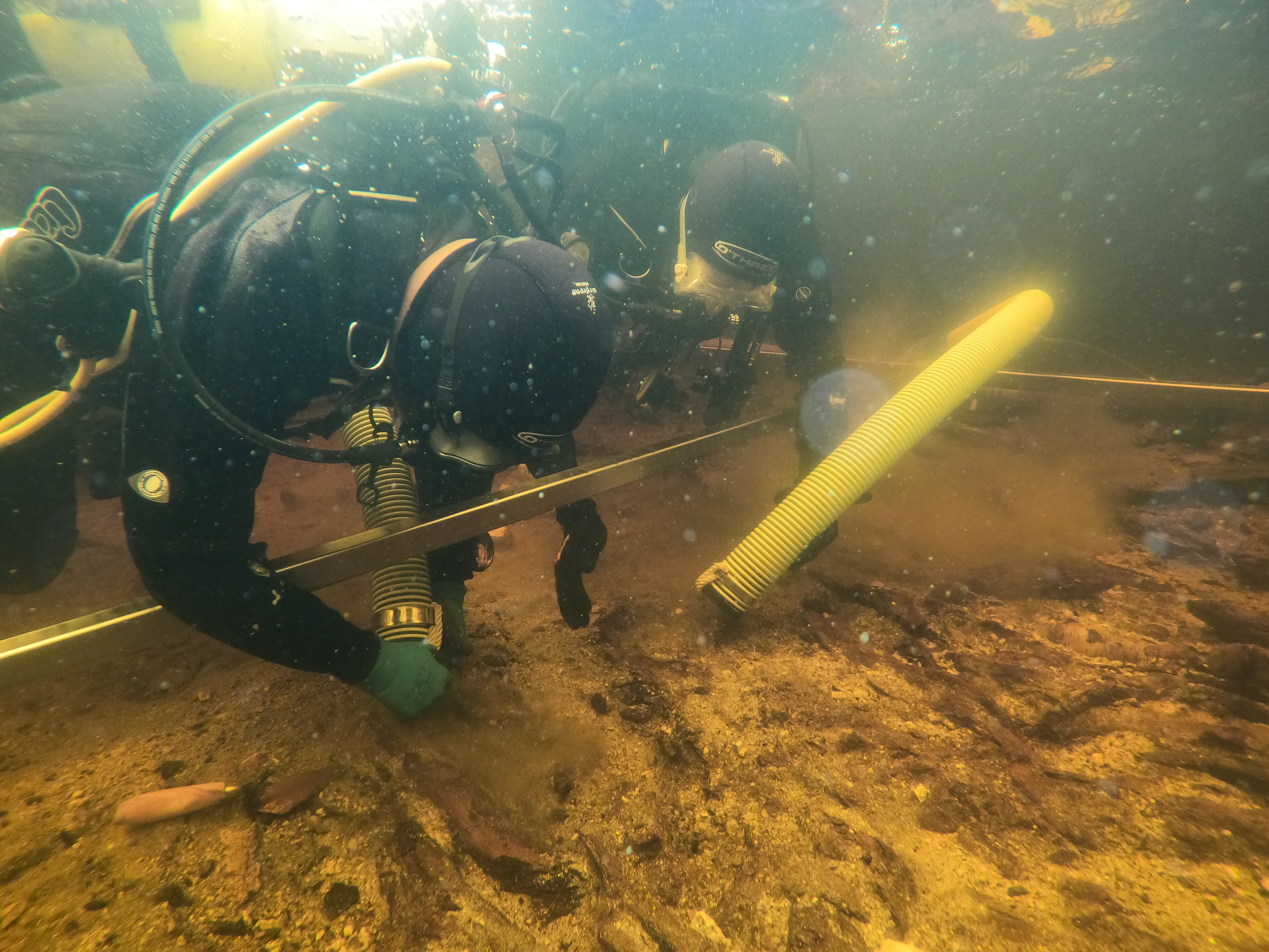
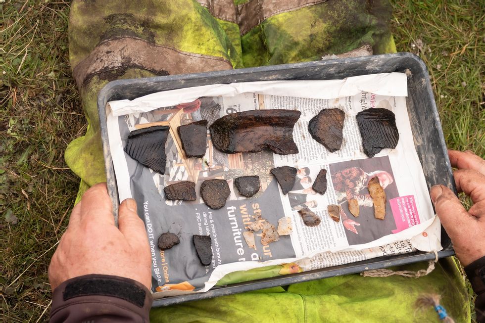
During fieldwork at the site, archaeologists discovered a layered construction of wood and brushwood beneath the stone surface, alongside hundreds of Neolithic pottery fragments submerged in the surrounding waters.
Dr Stephanie Blankshein, a University of Southampton archaeologist, said: "When we actually started excavating is when we realised that it was actually this coherent, quite large timber structure that was under what you would see as the stone island today."
She added: "So that was a big surprise, and that was in 2021 when we actually started digging down. Before that, we didn’t know. We just knew that there were pieces of wood sticking out and that there must have been some sort of structure there."
Working with experts from the University of Reading, they have now used a technique called stereophotogrammetry, which creates 3D computer imagery from multiple 2D photos, to show how the island appears above and below the waterline as a single continuous structure.
Dr Blankshein added: "Through excavating and through the photogrammetry work that we did, we were able to build a picture of this coherent timber structure, not just bits of wood supporting a stone mound with a kind of timber platform underneath, but actually, the timber itself was the basis of the structure.
"A lot of work went into it, we’ve had a lot of really good dates come out of it, and all the dates are aligning to about 3500 to 3300 BC across all the sites we’re seeing. So we know that this was an activity that wasn’t just taking place at this site, but other sites nearby and even on other islands throughout the Outer Hebrides."
She added: "While we still don’t know exactly why these islands were built, the resources and labour required to construct them suggests not only complex communities capable of such feats, but also the great significance of these sites."
LATEST DEVELOPMENTS:
- Real face of Anne Boleyn may finally be revealed after 'hiding in plain sight' for centuries
- Thief returns 800-year-old medieval tiles he stole from priory 59 years ago
- Dog walker unearths remarkable 3,000-year-old artefact dating back to Bronze Age
Working alongside experts from the University of Reading, the team employed stereophotogrammetry, a method that creates three-dimensional computer models from multiple two-dimensional photographs stitched together using specialist software.
Imaging in shallow water presents particular difficulties for archaeologists, as Professor Fraser Sturt, principal investigator and director of the Southampton Marine and Maritime Institute, explained: "Fine sediments, choppy conditions, floating vegetation and distorted or reflected light all hinder shallow water imaging.
"Photogrammetry is very effective in deep water but runs into problems at depths of less than a metre. This problem is a well- known frustration for archaeologists."
To overcome these challenges, the researchers developed a novel approach during their 2021 fieldwork, using two compact, waterproof cameras with strong low-light performance and wide-angle lenses, mounted on a frame at a fixed distance apart to ensure precise image overlap.
A diver manoeuvred the cameras through the water with centimetre-level precision, matching the accuracy of aerial drones.
Dr Blankshein explained the photogrammetry work revealed timber was the fundamental basis of the structure, rather than merely serving as a support for a stone mound.
The crannog began as a circular wooden platform measuring approximately 23 metres in diameter, covered with brushwood.
Some 2,000 years later, during the Middle Bronze Age, additional layers of brushwood and stone were added, with further activity in the Iron Age roughly 1,000 years later.
A stone causeway, now submerged, connects the loch shore to the island, which was initially discovered in 2009.
Our Standards: The GB News Editorial Charter

ملاحظة تحريرية | Editorial Note: نُشر هذا المقال في الأصل بواسطة GB News. خبر (Khabr) هي منصة إعلامية أردنية مرخّصة تعمل بالذكاء الاصطناعي. نضيف قيمة تحريرية من خلال: تحليل ذكي للأخبار، ملخصات تلقائية، رواية صوتية بالذكاء الاصطناعي، ترجمة متعددة اللغات، وتدقيق الحقائق. هدفنا جعل الأخبار أكثر وضوحاً وسهولةً للقارئ العربي.
This article was originally published by GB News. Khabr is a licensed Jordanian AI-powered news platform (Registration #82086). We add editorial value through: AI-powered news analysis, automated summaries, AI audio narration, multi-language translation (Arabic, English, French, Turkish), and AI fact-checking. Our mission is to make news more accessible and understandable for Arabic-speaking audiences worldwide.